Natural National Boarders
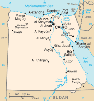 |
| Mediterranean and Red Seas. [6] |
Some of the greatest national boarders around Egypt have been
the Mediterranean and Red Seas. Both of these bodies of water provide a natural
boundary from enemies, consisting of over 2,500 kilometers of coastline.[1]
This vast amount of water in such close proximity to Egypt has had a profound impact on the
people who live near the coast. Because of the great abundance of water, many
people choose to use fishing as a way to provide financially for their
families. Fishermen take advantage of this, using the Mediterranean Sea to
catch 45% of the demanded fish. These water boundaries have not changed
throughout the years, remaining constant during the course of time.
European conquest
One of the main people groups that attempted to take over the Egyptian region was Bonaparte and and his French army. In July of 1798, Napoleon drove 35,000 of his soldiers straight into Egypt, desiring the great wealth of history, religion, and wealth that laid in its boarders.[2] Alexandria and Cairo were soon conquered, but not without a fight. Bonaparte, having taken over each of these cities, disrupted life for the Egyptians living there, causing them to fight back in order to keep their land.[2] French men battled against over 22,000 Middle Eastern soldiers, thousands of which lost their lives trying to defend their own land. This battle alone greatly disrupted Egyptian national boarders because Egypt no longer had control over Cairo and Alexandria. This was French land now, resulting in a loss of territory from what used to be Egypt.
 |
| Napoleon Bonaparte in 1796. [7] |
Muslim Conquest
 |
| Map of Egypt under Muhammad Ali. [6] |
The main difference in Ancient Egyptian borders and modern
Egypt is the literal line of where the country begins and ends. One of the
major changes happened throughout 1805-1914 when Muhammad Ali ruled over the
land with his powerful dynasty. There were many political modifications as
Muhammad desired to build a kingdom that stretched far and wide. Ali used his
militaristic strength to threaten the Ottoman Empire, eventually overpowering
them and expanding the borders of Egypt. Such power did provide a better
infrastructure for the country as a whole, adding many postal services,
railways, harbors, schools, canals, and irrigation systems.[3]
Modern War
 |
| Israeli fighter planes. [9] |
Egypt had settled its boarders in 1952, officially marking
out the defining points of the nation. This was a relatively peaceful time to
citizens throughout Egypt and Syria who united to create the United Arab
Republic.[4]
However, in 1967 the Six-Day war occurred due to boarder tensions between
Israel and Egypt. Israel launched air attacks over the Sinai Peninsula, gaining
control of the Suez Canal and Sinai Peninsula. This short war had great effects
on the people who lived specifically in the Sinai Peninsula, because they were
in the middle of battle in their everyday lives. By 1982, Egypt and Israel were
able to make a peace negotiation, returning the Sinai Peninsula to Egypt, thus
changing the national boundary again. [5]
This helped begin the restoration of relations between both countries' Prime
Ministers, commercial workers, and other diplomatic leaders.
[1] "FAO Fishery Country Profile - THE ARAB REPUBLIC OF EGYPT." FAO Fishery
Country Profile - THE ARAB REPUBLIC OF EGYPT. Accessed May 06, 2016.
http://www.fao.org/fi/oldsite/FCP/en/EGY/profile.htm.
[2] "The Egyptian Campaign." PBS. Accessed May 06, 2016. http://www.pbs.org/empires/napoleon/n_war/campaign/page_3.html.
[3] "Muhammad Ali Dynasty." - New World Encyclopedia. December 5, 2014.
Accessed May 06, 2016.
http://www.newworldencyclopedia.org/entry/Muhammad_Ali_Dynasty.
[4] "Egypt: Maps, History, Geography." Infoplease. 2016. Accessed May 06,
2016. http://www.infoplease.com/country/egypt.html?pageno=2.
[5]
History.com Staff. "Six-Day War Ends." History.com. 2010. Accessed
May 04, 2016. http://www.history.com/this-day-in-history/six-day-war-ends.
[6] CIA. The World Factbook. 2004. Egypt. https://commons.wikimedia.org/wiki/File:Egypt-CIA_WFB_Map.png
[7] Antoine-Jean Gros. Palace of Versailles. 1796. France. https://commons.wikimedia.org/wiki/File:1801_Antoine-Jean_Gros_-_Bonaparte_on_the_Bridge_at_Arcole.jpg
[8] https://commons.wikimedia.or/wiki/File:Egypt_under_Muhammad_Ali_Dynasty_map_de_2.png
[9] Zionism and Israel Information Center. Israel Mirage Jets returning from Egypt. 1967. http://www.zionism-israel.com/dic/6daywar.htm
[9] Zionism and Israel Information Center. Israel Mirage Jets returning from Egypt. 1967. http://www.zionism-israel.com/dic/6daywar.htm
No comments:
Post a Comment